Database of the Telford milestones along the A5 road across Wales 🏴
Compiled by R J Price
The Milestones are numbered from Holyhead and correspond to the number of miles from Holyhead.
In viewing the Telford Milestones along the A5 it is worth noting how important they were when they were placed, at a time when no motor vehicles existed. Passing them would have been the mail coaches, riders on horseback and all manner of horse drawn carriages as well as those on foot. It is not hard to imagine today, as we pass these mostly highly visible milestones as we travel on the A5, the passengers in the stagecoaches glancing at the milestones as they ticked off the miles on what was said by many to be a very tedious journey. I guess that on many a stagecoach journey children played 'Spot The Milestone' just as some may well still do today. One soon gets the hang of judging the distance of one mile between them as we search for them on our journey along the A5 that passes through some of the best scenery anywhere; the Vale of Llangollen, the rolling hills of Pentrefoelas, Betws-y-Coed, Swallow Falls, Ogwen Valley with the Idwal Slabs, Llyn Ogwen of Excalibur fame, Cwm Idwal with its magical Glacial Cirque and the Darwin Boulders, Nant Ffrancon, and of course the Menai Bridge which is the crowning glory of this route from the gates of Buckingham Palace to the Irish Mail Jetty in Holyhead - all down to that genius Thomas Telford. I guess that there was often an unofficial stop at the viewing point for the Menai Bridge (milestone 21) which is, debatably, with the backdrop of the mountains of Snowdonia, the finest view in the whole of Great Britain.
The mail coaches in particular travelled not only by day but also in the dark of night, aided only by oil lamps affixed to the coaches, and in all weathers; nothing could be allowed to delay the Mail which was the basis of all distant communication in those days. The system was so well-organised and efficient that as a mail coach approached a toll gate its post-horn was sounded. Toll-keepers who delayed the mail by failing to open the gate promptly were fined. Stagecoach travel was fraught with danger—not only from tragic accidents but also deliberate acts of sabotage, such as tree branches or farm gates placed in the road to trip the horses. Vandalism is not just a modern day occurrence.
An article cited later describes these events and these wanton acts of vandalism that occurred on these stage coach routes.
There was also a real threat from highway robbers: hence the armed guards on the stagecoaches.
This article: 'Thomas Telford: The Road to Holyhead' by David Ackerley' provides concise background information on the A5 road and in particular the building of the Menai Bridge across the Menai Strait.
See: How fast does a stagecoach go? and also Royal Oak and the Mail Coaches
"Google Maps updates may alter Street View images. If a milestone isn’t visible at a given link, searching the immediate area should still reveal it, as all coordinates listed are verified."
Of the 83 Telford milestones on the A5 across Wales, only one remains elusive — details below.
Tap on the blue links to access the locations on Google Maps and relating articles.
Codes used in this document:
☘️ = The milestone may be obscured by grass or shrubbery. 🏢 = Milestone is against a wall or recessed into a wall.
< > = Which side of the road when facing Holyhead. ⚠️ = Beware of danger from passing traffic.
Car parking space at: ⬅️ = Towards Holyhead from the Milestone. ➡️ = Towards London from the Milestone.
To physically visit a location, enter the given coordinates into your SatNav or GPS device.
|
No. |
Area / Town / Village |
GPS Location |
Viewable on Google Maps? |
Comment |
Parking Point to access. |
Inscription |
|
0 |
Irish Mail Jetty (Admiralty Pier), Salt Island, Holyhead. |
Yes, but not in Street View. |
Area is now operated by Stena. |
There is no public right of way to access. Seek permission. |
|
|
|
0 |
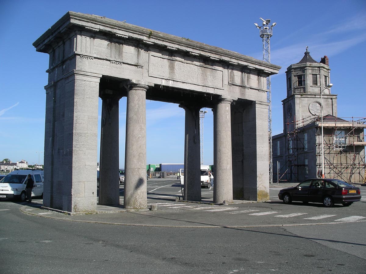
Admiralty Arch, Salt Island, Holyhead. (Built in 1824) |
See also: This Link |
Yes, but not in Street View. |
Area is now operated by Stena. |
There is no public right of way to access. Seek permission. |
An inscription on the arch is in Welsh and Latin. |
|
0 |
Yes < |
Clearly visible 🏢 |
Park at location. This is a recent commemorative stone and not an original. |
|
||
|
1 |
Holyhead, London Road |
Yes > |
Clearly visible 🏢 |
Parking space at location. |
Holyhead 1 Mona 12 Bangor 24 |
|
|
2 |
Holyhead, Penrhos Beach |
From the old OS map of 1842 - 1952 |
No |
This milestone is also shown on the old OS map dated 1888-1913 |
This location is on the site occupied by the former Anglesey Aluminium Plant. |
The quoted maps show that the milestone read: Holyhead 2 Bangor 23 |
|
3 |
Yes > |
Clearly visible 🏢 |
Parking space near by. |
Holyhead 3 Mona 10 Bangor 22 |
||
|
3 |
Tollgate. Stanley Embankment, Holyhead |
Moved from original location |
Yes |
Easy clear access. Original Telford iron gate. |
Parking space at location. The gates were painted white to make them more easily seen at night. |
|
|
3 |
Moved from original loc. |
Yes |
Now a cafe. Old relating photos etc. therein. |
Parking space at location. |
(This Tollhouse has been moved from its original location) |
|
|
4 |
Valley |
Yes > |
Clearly visible 🏢 |
Street parking near by. |
Holyhead 4 Mona 9 Bangor 21 |
|
|
5 |
Caergeiliog. (West of) |
Yes |
Vegetation often obscures. |
Parking in village. No pavement at location ⚠️ |
Holyhead 5 Mona 8 Bangor 20 |
|
|
5 |
Yes < |
Easy Access. |
Parking space near by. |
|
||
|
6 |
Caergeiliog |
Yes > |
Clearly visible 🏢 |
No pavement but is adjacent to two private driveways. |
Holyhead 6 Mona 7 Bangor 19 |
|
|
7 |
Bryngwran (West of) |
Yes > |
Clearly visible 🏢 ☘️ |
600' from a T-Junction ➡️ No pavement. ⚠️ |
Holyhead 7 Mona 6 Bangor 18 |
|
|
8 |
Bryngwran Village |
Yes > |
Clearly visible 🏢 |
Street parking near by. |
Holyhead 8 Mona 5 Bangor 17 |
|
|
9 |
Bryngwran. Junction with the B5112 road |
Yes > |
Clearly visible 🏢 ☘️ |
On a cross roads. No proper parking place. |
Holyhead 9 Mona 4 Bangor 16 |
|
|
10 |
Gwalchmai (West of) |
Yes > |
Clearly visible 🏢 |
300' from a driveway entrance ➡️. No proper pavement. ⚠️ |
Holyhead 10 Mona 3 Bangor 15 |
|
|
11 |
Gwalchmai (East of) |
Yes > |
Clearly visible 🏢. Set against arched feature. |
600' from a lay-by ➡️. No proper pavement. ⚠️ |
Holyhead 11 Mona 2 Bangor 14
|
|
|
11 |
Yes > |
Clearly visible. |
150' from a lay-by ➡️ |
——— |
||
|
12 |
Mona Airfield |
|
Yes. |
Vegetation often obscures. |
Driveway entrance 250' ⬅️ No proper pavement. |
Holyhead 12 Mona 1 Bangor 13 |
|
13 |
Mona |
Yes > |
Clearly visible 🏢 |
Small pull-in space opposite. No pavement. ⚠️ |
? Holyhead 13 Mona 0 Bangor 12. |
|
|
13 |
Mona Staging Inn |
Yes < |
Telford designed major Staging Inn. 1821. |
|
Check out uniquepropertybulletin for details. May still be For Sale! |
|
|
14 |
Rhostrehwfa |
Yes > |
Clearly visible. 🏢 ☘️? |
650' from a private driveway ⬅️ No proper pavement. ⚠️ |
Holyhead 14 Mona 1 Bangor 11 |
|
|
15 |
Llangefni turn off |
Yes > |
Clearly visible 🏢 ☘️? |
750' from a pull-in ➡️. No pavement. |
Holyhead 15 Mona 2 Bangor 10 |
|
|
16 |
Pentre Berw (West Of) |
Yes > |
Clearly visible 🏢 |
60' from a T-junction ⬅️. No pavement. Recessed into wall. |
Holyhead 16 Mona 3 Bangor 9 |
|
|
17 |
Gaerwen |
Yes > |
Clearly visible 🏢 |
Street parking in village. |
Holyhead 17 Mona 4 Bangor 8 |
|
|
18 |
Gaerwen (East of) |
Yes > |
Against wall with an arch feature 🏢 |
150' from a gateway pull-in ⬅️. No pavement. |
Holyhead 18 Mona 5 Bangor 7 |
|
|
19 |
Star (Llanfairpwll) |
Yes > |
Clearly visible 🏢 |
On a T-junction and adjacent to a pull-in bus stop ⬅️ |
Holyhead 19 Mona 6 Bangor 6 |
|
|
20 |
Llanfairpwllwgwyngyll |
Yes > |
Clearly visible 🏢 |
Street parking. Easy access. |
Holyhead 20 Mona 7 Bangor 5 |
|
|
21 |
Menai Bridge (by viewing lay-by) |
|
Yes > |
Clearly visible ☘️ |
300' from lay-by ➡️ . Easy access on pavement. |
Holyhead 21 Mona 8 Bangor 4 |
|
21 |
Llanfair Gate. |
Yes < |
Clearly visible. |
Street parking near by. Easy access on pavement. |
See below for complete text. |
|
|
22 |
Menai Bridge |
Yes > |
Clearly visible 🏢 |
At the gateway to St Mary's Church. Parking space near-by. |
Holyhead 22 Mona 9 Bangor 3 |
|
|
23 |
Yes < |
Clearly visible. |
Mainland end of the Menai Bridge structure. |
——— |
||
|
23 |
Tollgate. Menai Bridge. The original Telford iron gate. |
Yes < |
Clearly Visible |
Mainland end of the Menai Bridge structure. |
|
|
|
23 |
Upper Bangor |
Yes < |
Clearly visible 🏢. Set into a curved stone wall. |
Private driveways nearby. |
Holyhead 23 Mona 10 Bangor 2 |
|
|
24 |
Bangor (near train station) |
Yes < |
Clearly visible 🏢 |
Parking at train station. |
Holyhead 24 Mona 11 Bangor 1 |
|
|
25 |
Bangor, High Street (Junction with William St.) |
Yes < |
Clearly visible 🏢 |
Recessed into stone wall. Street parking adjacent. |
Holyhead 25 Mona 12 C.Curig 14M 3F |
|
|
26 |
Bangor, Maesgeirchen |
Yes < |
Clearly visible 🏢 |
On a T-junction. Pavement access. |
Holyhead 26 Bangor 1 C.Curig 13M 3F |
|
|
27 |
Tal-y-Bont |
Park car at : |
Not covered in Street View. <🔴 |
Clearly visible ☘️ Photo. Probably the best stone of them all to see. |
Parking area 450' ➡️ There is a Staging Alcove directly opposite the milestone. |
Holyhead 27 Bangor 2 C.Curig 12M 3F |
|
28 |
Tregarth, Ogwen Bridge |
Yes < |
Clearly visible 🏢 |
🏢 Opening to a parking area 150' ⬅️. Pavement. |
Holyhead 28 Bangor 3 C.Curig 11M 3F |
|
|
29 |
Bethesda (West of) |
Yes < |
Clearly visible 🏢 |
Pavement. Private driveway 180' ➡️ |
Holyhead 29 Bangor 4 C.Curig 10M 3F |
|
|
30 |
Bethesda |
Yes < |
Clearly visible 🏢 |
Pavement. Street parking. |
Holyhead 30 Bangor 5 C.Curig 9M 3F |
|
|
31 |
Bethesda (East Of) |
Yes > |
Clearly visible 🏢 |
Private driveway 500' ⬅️ |
Holyhead 31 Bangor 6 C.Curig 8M 3F |
|
|
32 |
Bethesda (East Of) |
Yes > |
Clearly visible 🏢 |
Pavement. Small pull-in at gateway to field 1500' ➡️ |
Holyhead 32 Bangor 7 C.Curig 7M 3F |
|
|
33 |
Nant Ffrancon |
Yes > |
Clearly visible 🏢 |
Pavement. Lay-by 550' ⬅️ |
Holyhead 33 Bangor 8 C.Curig 6M 3F |
|
|
34 |
Pen-y-Benglog |
Yes > |
Clearly visible 🏢 |
Pavement. Lay-by 250' ➡️ |
Holyhead 34 Bangor 9 C.Curig 5M 3F |
|
|
35 |
Llyn Ogwen |
Yes < |
Clearly visible 🏢 |
Pavement. Lay-by opposite. |
Holyhead 35 Bangor 10 C.Curig 4M 3F |
|
|
36 |
Nant y Benglog. West |
Yes < |
Clearly visible 🏢 |
Driveway opposite. |
Holyhead 36 Bangor 11 C.Curig 3M 3F |
|
|
37 |
Nant y Benglog. East |
Yes < |
Clearly visible 🏢 |
Narrow pavement. Private driveway / pull-in 450'⬅️ |
Holyhead 37 Bangor 12 C.Curig 2M 3F |
|
|
38 |
Capel Curig (West of) |
Yes < |
Clearly visible 🏢 |
Narrow pavement. Private driveway 250' ➡️ |
Holyhead 38 Bangor 13 C.Curig 1M 3F |
|
|
39 |
Capel Curig (North of) |
Yes < |
Clearly visible 🏢 |
Narrow Pavement. Private driveway 500' ⬅️ |
Holyhead 39 Bangor 14 C.Curig 3 Furlongs |
|
|
40 |
Capel Curig (East of) |
Yes > |
Clearly vyisible ☘️ |
Pavement. 400' to Cobden's Hotel carpark ➡️ |
Holyhead 40 C.Curig 5 Furlongs Cernioge 13M 6F |
|
|
41 |
Capel Curig. Pont Cyfyng |
Yes > |
Clearly visible 🏢 |
Narrow pavement. Private driveway 950' ➡️ |
Holyhead 41 C.Curig 1M 3 F Cernioge 12M 6F |
|
|
42 |
Ugly House |
Yes > |
Clearly visible 🏢 |
Park at Ugly House 550' ⬅️ |
Holyhead 42 C.Curig 2M 5F Cernioge 11M 6F |
|
|
43 |
Pentre Du |
Yes > |
Clearly visible 🏢 |
Park opposite at road to forest. |
Holyhead 43 C.Curig 3M 5F Cernioge 10M 6F |
|
|
44 |
Betws y Coed (West of) |
Yes > |
Clearly visible 🏢 |
Park opposite on Ffordd Gethin. |
Holyhead 44 C.Curig 4M-5F Cernioge 9M 6F |
|
|
45 |
Betws-y-Coed |
Yes > |
Clearly visible 🏢 |
Driveway 200' ➡️ |
Holy-Head 45 C Curig 5M-5F Cernioge 8M-6F |
|
|
46 |
Fairy Glen |
Yes > |
🏢 ☘️ often obscured |
Driveway 100' ⬅️. Narrow pavement on bend. ⚠️ |
Holy-Head 46 C Curig 6M-5F Cernioge 7M-6F |
|
|
47 |
Conwy Falls |
Yes > |
☘️ |
Car park opposite. No pavement. ⚠️ |
Holy-Head 47 C Curig 7M-5F Cernioge 6M-6F |
|
|
48 |
Rhydlanfair |
Yes > |
☘️ ☘️ |
Private driveway 150' ➡️. No pavement. ⚠️ |
Holy-Head 48 C Curig 8M-5F Cernioge 5M-6F |
|
|
49 |
Glan Conwy (Betws-y-Coed) |
Yes > |
Clearly visible 🏢 |
Gateway pull-in opposite 100' ⬅️. No pavement. ⚠️ |
Holy-Head 49 C Curig 9M-5F Cernioge 4M-6F |
|
|
50 |
Pentrefoelas (West of) |
Yes > |
Clearly visible 🏢 |
Driveway pull-in 200' ➡️ Pavement. |
Holy-Head 50 C Curig 10M-5F Cernioge 3M-6F |
|
|
51 |
Pentrefoelas (Aber Pwll) |
Yes > |
☘️ ☘️ |
1000' to a T-Junction ⬅️ Parking difficult? Pavement. |
Holy-Head 51 C Curig 11M-5F Cernioge 2M-6F |
|
|
52 |
Pentrefoelas (East of) |
Yes > |
Clearly visible 🏢 |
500' to a pull-in ➡️. Pavement. |
Holy-Head 52 C Curig 12M-5F Cernioge 1M-6F |
|
|
53 |
Cernioge |
Yes > |
Clearly visible 🏢 Note the adjacent alcove. |
120' to a (private?) pull-in ⬅️ Pavement, |
Holy-Head 53 C.Curig 13M-5F Cernioge 0M-6F |
|
|
53 |
Cernioge Staging Inn |
Yes < |
See: Cernioge |
|
——— |
|
|
54 |
Pentrefoelas, Cernioge |
Yes > |
Clearly visible 🏢. Recessed into wall. |
700' to a driveway entrance ➡️. Pavement. |
Holy-Head 54 Cernioge 2 Furlongs Corwen 12M 6F |
|
|
55 |
Pentrefoelas (Glaslyn) |
Yes > |
Clearly visible |
200' to a driveway entrance ⬅️. Pavement. |
Holy-Head 55 Cernioge 1M 2F Corwen 11M 6F |
|
|
56 |
Cerrigydrudion (West of) |
Yes > |
Clearly visible ☘️ ? |
Park at Dragonfly Café. ⬅️. Entrance is just 70' away. |
Holy-Head 56 Cernioge 2M 2F Corwen 10M 6F |
|
|
57 |
Cerrigydrudion |
Yes > |
Clearly visible 🏢Recessed into a low wall. |
Park opposite at café. (Plate has been stolen?) |
Holy-Head 57 Cernioge 3M 2F Corwen 9M 6F |
|
|
58 |
Cerrigydrudion (East of) |
Yes > |
Clear, but risky walk. ☘️ ? |
500' to a driveway ⬅️. There is no pavement here on this fast stretch of road. ⚠️ |
Holy-Head 58 Cernioge 4M 2F Corwen 8M 6F |
|
|
59 |
Cerrigydrudion (South East of) |
Yes > |
Clearly visible. 🏢 ☘️? Recessed into a low wall. |
250' to a driveway ⬅️. Pavement. |
Holy-Head 59 Cernioge 5M 2F Corwen 7M 6F |
|
|
60 |
Cerrigydrudion (South East of) |
Yes > |
Clear, but risky walk. ☘️ Vegetation may obscure. |
350' to a driveway. There is no pavement here on this fast stretch of road. ⚠️ |
Holy-Head 60 Cernioge 6M 2F Corwen 6M 6F |
|
|
61 |
Corwen, Ty-Nant |
Yes > |
Set back into bushes. |
52.987197n 3.503472w is the start point of the path to access the bypassed portion of the A5. Turn off at 52.989533n 3.504602w |
Holy-Head 61 Cernioge 7M 2F Corwen 5M 6F |
|
|
62 |
Maerdy (West of) |
Yes > |
Clearly visible 🏢 ☘️ |
1100' to a T-junction ⬅️. Pavement. |
Holy-Head 62 Cernioge 8M 2F Corwen 4M 6F |
|
|
63 |
Maerdy (East of) |
Yes > |
Clearly Visible 🏢 |
90' to a gateway pull-in ⬅️. Pavement. |
Holy-Head 63 Cernioge 9M 2F Corwen 3M 6F |
|
|
64 |
Druid |
Yes > |
Clearly Visible 🏢 |
1600' to parking spot ➡️. Pavement. Easy safe walk. |
Holy-Head 64 Cernioge 10M 2F Corwen 2M 6F |
|
|
65 |
Tollgate. Corwen (West of) |
Yes |
Appears to be an original Telford Iron Gate |
Near to a T-junction ⬅️ |
——— |
|
|
65 |
Corwen (West of) |
|
Yes > |
Clearly visible 🏢 |
Near to a T-junction ⬅️ and adjacent to the Telford Gate. |
Holy-Head 65 Cernioge 11M 2F Corwen 1M 6F |
|
66 |
Corwen, Nant y Cefn |
Yes > |
Clearly Visible ☘️ |
150' to a gateway ⬅️. Pavement. Easy safe walk. |
Holy-Head 66 Cernioge 12M 2F Corwen 0M 6F |
|
|
67 |
Corwen |
Yes > |
Clearly Visible 🏢 |
Street parking nearby. Easy safe walk. |
Holy-Head 67 Corwen 2 Furlong Llangollen 9M 6F |
|
|
68 |
Nant Llechog |
Yes > |
Clearly Visible 🏢 |
300' to a gateway ➡️. Pavement. Easy safe walk. |
Holy-Head 68 Corwen 1M 2F Llangollen 8M 6F |
|
|
69 |
Llidiart y Nant (West of) |
Yes < |
Visible. ☘️ |
This milestone is in a lay-by but is Often obscured by vegetation |
Holy-Head 69 Corwen 2M 2F Llangollen 7M 6F |
|
|
70 |
Llidiart y Parc (East of) |
Yes > |
Clearly Visible 🏢 |
Street parking adjacent. |
Holy-Head 70 Corwen 3M 2F Llangollen 6M 6F |
|
|
71 |
Staging Inn, Berwyn Arms |
Yes > |
Coaching Inn. Grade 2 listed. Established 1359. |
——— |
||
|
71 |
Glyndyfrdwy (West of) |
Yes > |
Clearly Visible 🏢 ☘️? |
200' to parking at Berwyn Arms. est. 1359. ➡️ |
Holy-Head 71 Corwen 4M 2F Llangollen 5M 6F |
|
|
72 |
Glyndyfrdwy |
Yes > |
Easy access . ☘️ ☘️ |
Adjacent to a driveway entrance ⬅️ |
Holy-Head 72 Corwen 5M 2F Llangollen 4M 6F |
|
|
73 |
Glyndyfrdwy (East of) |
Yes < |
Clearly Visible 🏢 |
This milestone is in a lay-by. |
Holy-Head 73 Corwen 6M-2F Llangollen 3M-6F |
|
|
73 |
Tollhouse, Glyndyfrdwy |
Yes < |
|
Lay-by 400' ⬅️ |
——— |
|
|
74 |
Llantysilio (Hairpin Bend) |
Yes > |
Clearly Visible 🏢 Recessed into a low wall. |
750' from a lay-by ➡️. Pavement. |
Holy-Head 74 Corwen 7M-2F Llangollen 2M-6F |
|
|
75 |
Chain Bridge, Llantysilio (See Note Below) |
Yes > |
Clearly Visible 🏢 |
T-junction ⬅️ and parking 200' Pavement. |
Holy-Head 75 Corwen 8M-2F Llangollen 1M-6F |
|
|
76 |
Llangollen, (North West of) |
Yes > |
Clearly Visible 🏢 |
Adjacent parking. |
Holy-Head 76 Corwen 9M-2F Llangollen 0M-6F |
|
|
77 |
Llangollen |
Yes > |
Clearly Visible 🏢 |
Adjacent parking. Read the sign above the adjacent gate. |
Holy-Head 77 Llangollen 2F Chirk B 6M 5F |
|
|
78 |
Llangollen (East of) |
Yes > |
Clearly Visible 🏢 |
180' to driveway entrance ⬅️ Pavement. |
Holy-Head 78 Llangollen 1M 2F Chirk B 5M 5F |
|
|
79 |
Llangollen - Froncysyllte mid way. |
Yes < |
Clearly Visible 🏢 |
250' to lay-by ⬅️ Pavement |
Holy-Head 79 Llangollen 2M 2F Chirk B 4M 5F |
|
|
80 |
Froncysyllte (West of) |
Yes < |
Clearly Visible 🏢 ☘️ Set against a stone arch. |
150' to driveway entrance ⬅️ Pavement. |
Holy-Head 80 Llangollen 3M 2F Chirk B 3M 5F |
|
|
81 |
Froncysyllte (East of) |
Yes < |
Clearly Visible 🏢 |
300' to a T-junction ➡️ |
H.Head 81 Llangollen 4M 2F Chirk B 2M 5F |
|
|
82 |
Chirk (North of) |
Yes < |
Clearly Visible 🏢 |
Gateway pull-in ⬅️ 50' |
H.Head 82 Llangollen 5M 2F Chirk B 1M 5F |
|
|
83 |
Chirk (First stone in Wales) |
Yes < |
Clearly Visible 🏢 ☘️ but latest Google Earth image does not show. |
Street parking opposite. |
H.Head 83 Llangollen 6M 2F Chirk B 0M 5F |
|
|
84 |
Chirk Bank. Over the border in England 🏴 |
Yes < |
Easy access. Freestanding in parking space. |
Street parking close by. |
Holy-Head 84-M Salop 22M-6F |
|
|
|
Marble Arch. Start point of the A5 in London. |
Now at: |
Yes |
Originally at the entrance to Buckingham Palace. |
Was relocated from just outside Buckingham Palace 1847-1851. |
Check out interesting facts on The Story of Marble Arch and also 'Marble Arch Details' |
Note Regarding Software: This database was compiled using an Apple iPad and the PAGES app. Opening the blue text links should take you to the respective location on Google Maps. If you experience problems in opening these links it is likely to be because you are not running the latest versions of the software. If necessary, the respective GPS coordinates can be copied and entered into Google Maps or Google Earth instead.
All links in the document have been checked and are functioning correctly at the time of issue.
The software versions used are as follows:
iPad 5th Generation running iOS version 14.4.2 PAGES Version 5.1(6569) Google Maps Version (25.20.0)
This link gives details and photos of the Royal Mail Stagecoaches: Mail Coaches in the U.K. in the 1700 and 1800s (Geriwalton.com)
General Notes:
Re Milestone No.21, Tollhouse Charges Board at Llanfairpwllgwyngyllgogerychwyrndrobwllllantysiliogogogoch in
Anglesey:
Tolls to be taken at LLANFAIR GATE:
For every Horse, Mule or other Cattle, drawing any Coach or other Carriages, with springs, the sum of 4d.
For every Horse, Mule or other Beast or Cattle, drawing any Waggon, Cart, or other such Carriage,
not employed solely in carrying or going empty to fetch Lime for manure the sum of 3d.
For every Horse, Mule or other Beast or Cattle. drawing any Waggon, Cart, or other such Carriage,
employed solely in carrying or going empty to fetch Lime for manure the sum of 1½d.
For every Horse, Mule or Ass laden or unladen, and not drawing, the sum of 1d.
For every Drove of Oxen, Cows or other neat Cattle per score, the sum of 10d.
For every Drove of Calves, Sheep, Lambs or pigs per score, the sum of 5d.
For every Horse, Mule or other Beast drawing any Waggon or Cart the Wheels being less than 3 inches
breadth or having Wheels with Tires fastened with Nails projecting and not countersunk to pay double Toll.
A Ticket taken here clears Carnedd Du Bar. (Link to photo)
Re Milestone No. 2 - This is the only milestone in this list that I have failed to find. It was almost certainly removed from its place when the Anglesey Aluminium Plant (owned by Rio Tinto) was constructed around 1970. Its location, estimated from the 1888-1913 OS map, places it where buildings now stand. It is highly unlikely that the stone was simply discarded - someone must know what happened to it.
Each Telford milestone originally measured around six feet in length and weighed over 250 pounds. Due to extensive road resurfacing since they were placed, almost two hundred years ago, the resulting rise of the ground level makes them now appear to be much smaller. No.27 at Tal-y-Bont is perhaps the best one to see to get an impression of their original appearance and size; it still stands at 4' 6” above ground level. Imperial units are used throughout this document as this fits with the time period in history and also with the standard units for travel and road signs in the UK still being 'Miles'. When discussing Britain's historical routes, 'miles' feel far more appropriate than the metric kilometre, especially given the legacy of Roman roads, Roman Miles - 1,000 paces - 'Mille Passus' - origin of the word mile, and Roman milestones, some of which still exist in Wales.
All records consulted suggest that there never was a milestone at the zero point in Holyhead. Stepping back one mile from milestone No.1 in London Road, along the route of the original road, takes us exactly to the mid point of the Irish Mail Jetty just where the mail would have been transferred to the ships under armed guard. This is the logical point zero. On the 1888-1913 OS map there is no milestone shown in this area which in itself suggests that there never was one.
Preliminary searches of other roads in North Wales indicate poor survival rates for our milestones, although many are undoubtedly concealed in dense roadside vegetation. An exception is the A545 Menai Bridge to Beaumaris road, where all five milestones are visible. On the Welsh portion of the A5 the milestones are pleasingly all there to be seen, except for No.2, as already mentioned.
This compilation of the milestones does not take into account the fact that some of the milestones may not be the originals, as are the recessed cast iron plates which display the place names and distances. A Welsh government project some years back recognised the historical importance of these milestones and undertook work to preserve/protect them, but did they forget or overlook our elusive No 2? Anglesey County Council seem to have failed in their duty to preserve the milestone - what of the mandatory site inspections and 'building regulation approval' during construction of the Anglesey Aluminium buildings? However, maybe the Grade 2 protection was not in force at the time the aluminium plant was being constructed.
Note re Milestone No. 75: Mounted on the wall to the right of the entrance to the Corn Mill in Llangollen (52.970734°N 3.171137°W) is what appears to be the original cast iron plate from Milestone No. 75. (Thanks to Steve and Clare for spotting it during their visit there and letting me know of its existence.) The original milestone (see 52.979850n 3.197611w) bears visible damage, showing where the stone was broken to insert a pry bar behind the cast iron plate for removal. The plates were inset into the stones to make them more difficult to remove. Steel pegs or nails secured the plates, likely driven into lead-sleeved holes. Who stole the original plate and mounted it on the wall at the Corn Mill? When did this happen? Vandals are by no means just a modern day blight.
Alcoves along the A5:
Associated with the A5 and Thomas Telford are approximately 300 Alcoves (Storage Recesses) that were used for storing road repair materials such as stones, gravel and grit; the grit also being available to spread on snow/ice during severe weather - particularly relevant on the likes of the Nant Ffrancon pass, where some fine examples can be seen. These alcoves can easily be seen almost anywhere along the route. The alcoves are either rectangular, about 16' x 8' (example at 53.263091n 4.448941w), or semi-circular, about 16' wide (example at 53.138031n 4.028277w). It is interesting to note that these alcoves were located on the side of the road that gave them maximum sunlight, thus keeping the gravel drier and less likely to get frozen.
Also associated with the A5 Trunk Road and the milestones are many tollhouses, staging posts and inns. Only a few have been included here as examples. Many of the tollhouses have been destroyed but how wonderful it is that all the ones in Anglesey survive. An indication of the scale of the organisation and logistics needed to support the mail service from London to Holyhead, a journey that took twenty seven hours and was 252 miles long, is that the teams of four horses were changed at approximately every twelve miles. So in round figures there were twenty staging posts along the route, each having eight horses (not counting standbys and young trainee horses) making a total of 160 horses. Each mail coach would therefore utilise eighty horses on one journey from London to holyhead.
The teams of horses typically worked back and forth between just two stabling points and were rested for twenty-four hours before being hitched up to a coach returning in the opposite direction. The change-over is recorded as being completed in just two minutes - such was the organisation and efficiency of this amazing undertaking; compare to the way today's grand prix teams change a set of wheels on racing cars. The horses seem to have carried out their duty with impeccable determination and pride, knowing that a good meal and a comfy bed awaited them at their destination. The mail coaches did not stop at the toll points; the guard on the coach sounded a horn (post horn) to alert the toll keeper of their approach and to open the gate. Failure to open the gate, thus causing the coach to slow down or stop would incur the toll keeper a fine. The guard was armed with a Blunderbuss Pistol complete with a spring loaded Bayonet, and two further Flintlock Pistols. Open this link for some interesting facts from the Postal Museum.
The A5 milestones were designed by Thomas Telford and made from limestone quarried from near Red Wharf Bay, Anglesey, the same source as some of the stone used in constructing both bridges across the Menai Strait and Admiralty Arch on Salt Island, Holyhead. Some sources state that the stone for the Menai bridges came from a site in Penmon.
The remarkable survival rate of these milestones is undoubtedly due to the precision of Thomas Telford’s design, specifications, and supervision—just as with all his other engineering masterpieces. The title of ”Colossus of Roads” which his friends bestowed upon him is certainly very fitting. but even that title falls short of what he deserves since he was also a master of canal building with the Froncysyllte Aqueduct, Caledonian Canal and the Göta Canal in Sweden being just a few examples of his work. His suspension bridges over the Menai Strait and the Conwy Estuary were groundbreaking—the first of their kind in the world, setting a new standard for engineering for years to come.
In compiling this list and searching for other Milestones not on the A5 it becomes clear that there should be a standardised way of marking the location of these milestones on the actual kerb stone or gutter of the road, such as a 6” square in a suitable colour; this would be particularly useful out in the rural areas where vegetation often obscures these milestones, particularly during the summer months. This would be invaluable in alerting those using heavy machinery for grass and hedge cutting, preventing the kind of damage already visible on many of the remaining milestones. - A damaged milestone on the A470 at the Waterloo Bridge in Betws-y-Coed: (53.0862051, -3.7945905)
Historic milestones are protected by law but ways of preventing them from becoming damaged by machinery and road works is clearly lacking. Maybe the best way to preserve the stones and reduce damage is to concrete a square yard or so around the stones where they now sit in grass and vegetation.
This project began with a simple question after spotting Milestone No. 45 in Betws-y-Coed—were there others like it?Using an Ordnance Survey Map it showed the location of many of the milestones and using Google Earth and Google Maps it was possible to locate most of them. Having completed this exercise on the A5 the same procedure was applied to other roads, mainly in Wales, but also Scotland and England. The key to finding many of them was to use old Victorian Ordnance Survey maps.
If this document has whetted your appetite for the facts about our ancient roads I highly recommend the book: "The Life of Thomas Telford; civil engineer with an introductory history of roads and travelling in Great Britain" by Samuel Smiles.
This document may be freely used and copied towards promoting interest in, and the preservation of our historic milestones. It would be appreciated if this work is used in further work or documents that it be credited to me as the original creator, R J Price. I believe the layout and presentation to be superior in that it utilises the latest technology to accurately record the exact locations in GPS decimal degree coordinates rather than the usual Ordnance Survey Grid which is pretty useless in respect of accuracy. It is hoped that others will use this format to add their input and effort to finding and recording the many milestones across the land. It is said that there are just two in the Elan Valley; can you find more? This link is a good starting point: OS map of Wales 1888 - 1915.
Please note that Google Maps now allows one to add photos in Street View, and many of our milestones are deserving of a decent photograph to supplement the often poor quality images in Street View. If you have good photos of any milestones, including the ones above, please add them to Google Maps
See: Telford's Irish Mail Road Tour https://historypoints.org/index.php?page=telford-s-irish-mail-road-tour
Link to Daily Post article: https://www.dailypost.co.uk/news/north-wales-news/mysterious-loss-historic-road-feature-31759998
Congratulations on an amazing piece of work! Thanks for sharing.
ReplyDeleteThe location is under the aluminium works here. https://maps.app.goo.gl/FxFvZJrPoXaQ513b8 It was a couple of us from the https://www.facebook.com/groups/MilestoneSociety that contacted Stena and also the Anglesey County Council about it. There is a replica plate held at Oriel Mon Museum/Gallery.
ReplyDeletehttps://maps.nls.uk/geo/explore/#zoom=14.7&lat=53.30174&lon=-4.61149&layers=6&b=1&o=100&marker=53.298588,-4.608185 This is the location on the old NLS maps (invaluable for finding MSs and BSs).
ReplyDeletehttps://www.facebook.com/groups/angleseyhistory/permalink/1424201245410601/ From:
ReplyDeleteGreat work John, thanks for sharing. Looking forward to more blogging about Thomas Telford.
ReplyDelete